
 Facebook
 X
X
 Pinterest
 Copy Link
Fire Zones and Insurance: What Land Investors Need to Know in Central California
Wildfire risk isn’t just a buzzword in the Central California foothills — it’s one of the biggest factors shaping insurance costs, land values, and long-term development feasibility. Whether you’re looking at Oakhurst, Coarsegold, Ahwahnee, North Fork, or anywhere along the Highway 41/49 corridors, fire zones determine far more than most buyers realize.
If you’re planning to invest in land — especially raw or lightly improved acreage — this is one topic you cannot skip.
Below is the complete guide to understanding fire risk, insurance, compliance requirements, and how all of this impacts your investment.
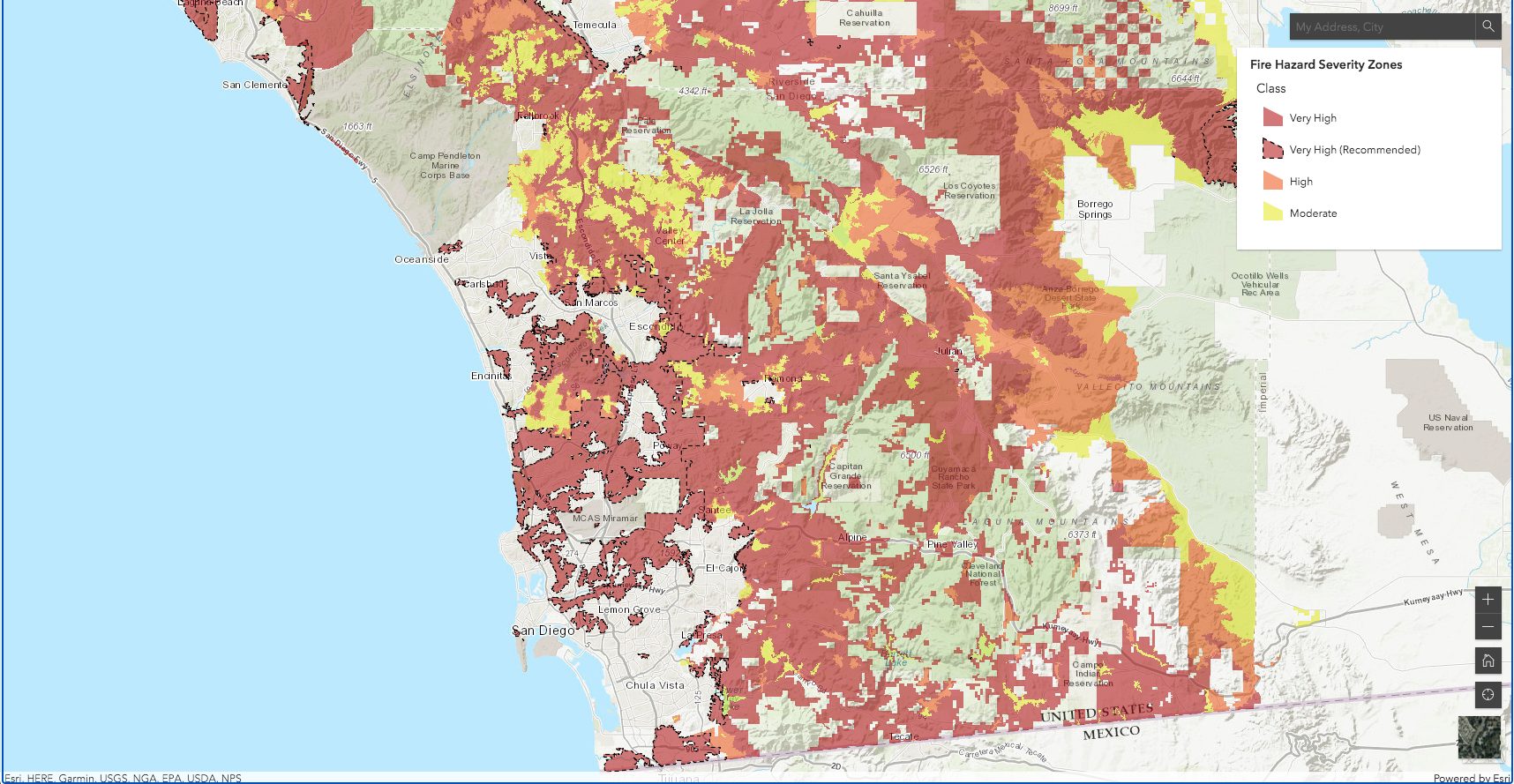
1. What Are Fire Hazard Severity Zones?
California designates three main wildfire risk tiers for State Responsibility Areas (SRA):
-
Moderate
-
High
-
Very High Fire Hazard Severity Zone (VHFHSZ)
Most of the Central California foothills fall into High or Very High, especially:
-
Oakhurst (93644)
-
Coarsegold (93614)
-
North Fork (93643)
-
Mariposa County borders
-
Bass Lake region
How to check the fire hazard severity for a parcel
CAL FIRE provides the official mapping tool:
🔗 CAL FIRE Fire Hazard Severity Zone Map
https://egis.fire.ca.gov/FHSZ/
You can look up an APN or zoom in manually.
2. Insurance Is Getting Harder — Here’s Why It Matters
Wildfire risk affects:
✔ Insurance availability
✔ Insurance cost
✔ Lender requirements
✔ Future resale value
✔ Buildability
✔ Feasibility of short-term rentals or long-term rentals
In many high-risk zones, buyers are getting:
-
Quotes 3–8× higher than they expected
-
“Surplus line” (non-admitted) carriers
-
FAIR Plan + wraparound policies
What is the FAIR Plan?
When no carrier will issue a standard policy, California’s FAIR Plan provides basic fire coverage.
🔗 California FAIR Plan
https://www.cfpnet.com/
Most homeowners then add a “difference in conditions” (DIC) policy for liability, theft, water damage, etc.
3. How Insurance Impacts Land Purchases
If you’re buying raw land, the insurance conversation really matters when:
-
You plan to build
-
You plan to rent the future home
-
You need construction insurance
-
You need coverage during grading or infrastructure work
Key point:
Some lenders won’t fund construction loans in VHFHSZ zones unless insurance is secured first.
This can make or break a deal.
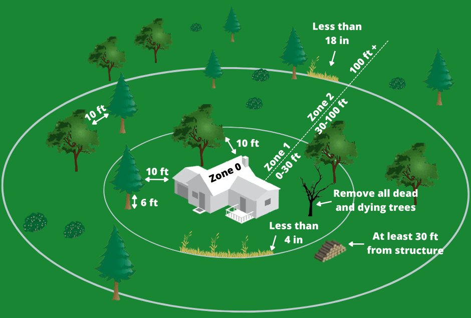
4. Defensible Space Laws You Must Know (100-Foot Rule)
California requires 100 feet of defensible space around all structures — and this affects not just homes, but also:
-
ADUs
-
Cabins
-
Sheds

-
Short-term rentals
These requirements are enforced by CAL FIRE:
🔗 CAL FIRE Defensible Space Requirements
https://www.fire.ca.gov/programs/communications/defensible-space-prc-4291/
You must clear:
-
Flammable brush
-
Dead trees
-
Ladder fuels
-
Excess vegetation
For buyers, this means two things:
-
Your future building site must have enough room to create defensible space.
-
If the lot is heavily forested, clearing may cost $5,000–$40,000+ depending on density and slope.
5. Fire Hardening Requirements for New Builds
Homes built in the foothills must meet the Wildland Urban Interface (WUI) building codes, including:
-
Class A fire-rated roof
-
Non-combustible siding materials
-
Tempered glazing
-
 Ember-resistant attic vents
 -
Defensible space planning
 Ember-resistant attic vents
Official resource:
🔗 California Building Code – Wildland Urban Interface (WUI) Requirements
https://osfm.fire.ca.gov/divisions/wildfire-planning-engineering/building-codes/
These regulations increase construction cost, but they also increase long-term safety and insurance eligibility.
6. Understanding Fire Behavior in the Foothills
Fire moves differently in the Sierra foothills due to:
-
Steep slopes
-
Dense vegetation
-
Afternoon up-canyon winds
-
Fuel buildup
-
Rural access limitations
Buyers should evaluate:
-
How steep the parcel is
-
Whether the driveway is long/narrow
-
Whether fire trucks can access the property
-
If there is a cleared building pad
-
Whether neighboring lots are maintained
Many buyers overlook the neighbor’s defensible space compliance, which affects your insurance eligibility.
7. How Fire Zones Affect Land Value
1. High-risk areas appreciate slower
Land in VHFHSZ areas may:
-
Sit longer on market
-
Appreciate slower
-
Cost more to develop
But it may also sell much cheaper upfront, which attracts investors.
2. Existing improvements raise value
Parcels with:
-
Cleared pads
-
Driveways
-
Water
-
Power
-
Septic
-
Established defensible space
…are worth significantly more and easier to insure.
3. Some buyers avoid high-risk zones entirely
Meaning reduced buyer pool, but also less competition for savvy investors.
8. How to Protect Yourself as a Land Buyer
Here’s your fire-risk due diligence checklist:
✔ 1. Check CAL FIRE hazard severity maps
See whether the parcel is Moderate, High, or Very High.
✔ 2. Get insurance quotes early
Don’t wait until escrow is almost closed.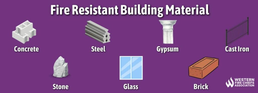
✔ 3. Ask about defensible space violations
Sellers must disclose vegetation hazards.
✔ 4. Inspect tree density and slope
Steep parcels cost more to clear.
✔ 5. Evaluate access for emergency vehicles
Driveway width matters.
✔ 6. Research nearby fire history
Use Cal Fire’s incident map:
🔗 CAL FIRE Incident Map
https://www.fire.ca.gov/incidents/
✔ 7. Confirm hydrant distance (if applicable)
Some areas require water storage tanks if hydrants aren’t nearby.
✔ 8. Analyze insurance + clearing costs in your ROI
Especially for investment or development projects.


